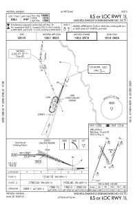
IAC chart of KICT
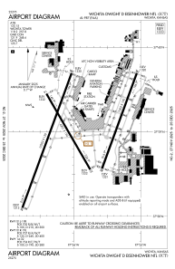
 ADC chart of KICT
 Satellite view of KICT
ADC chart of KICT
Satellite view of KICT
Sorry, we have no imagery here.
Sorry, we have no imagery here.
Sorry, we have no imagery here.
Sorry, we have no imagery here.
Sorry, we have no imagery here.
Sorry, we have no imagery here.


KICT - Wichita Dwight D Eisenhower Ntl
Located in Wichita, United States
ICAO - ICT, IATA - ICT
Data provided by AirmateGeneral information
Coordinates: N37°38'60" W97°25'59"
Elevation is 1332 feet MSL.
Magnetic variation is 04° East View others Airports in Kansas
Operational data
Special qualification required
Current time UTC:
Current local time:
Weather
METAR: KICT 010153Z COR 14005KT 10SM SCT150 SCT200 10/03 A2995 RMK AO2 SLP146 T01000028
TAF: KICT 312338Z 0100/0124 15008KT P6SM SCT150 FM011000 14015G25KT P6SM SCT015 BKN200 FM011600 18025G35KT P6SM SCT015 BKN200
Communications frequencies: [VIEW]
Runways:
| RWY identifier | QFU | Length (ft) | Width (ft) | Surface | LDA (ft) |
| 01L | 20° | 10302 | 150 | CONC | 10301 |
| 19R | 200° | 10302 | 150 | CONC | 10301 |
| 01R | 20° | 7302 | 150 | CONC | 7302 |
| 19L | 200° | 7302 | 150 | CONC | 7302 |
| 14 | 150° | 6301 | 150 | CONC | 6301 |
| 32 | 330° | 6301 | 150 | CONC | 6301 |
Airport contact information
Address: Wichita United States
Other aviation service providers
Repair station

Flight schools

Satellite view of KICT
Sorry, we have no imagery here.
Sorry, we have no imagery here.
Sorry, we have no imagery here.
Sorry, we have no imagery here.
Sorry, we have no imagery here.
Sorry, we have no imagery here.