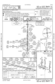
IAC chart of KIAD
 ADC chart of KIAD
 Satellite view of KIAD
ADC chart of KIAD
Satellite view of KIAD
Sorry, we have no imagery here.
Sorry, we have no imagery here.
Sorry, we have no imagery here.
Sorry, we have no imagery here.
Sorry, we have no imagery here.
Sorry, we have no imagery here.


KIAD - Washington Dulles Intl
Located in Washington, United States
ICAO - IAD, IATA - IAD
Data provided by AirmateGeneral information
Coordinates: N38°56'51" W77°27'36"
Elevation is 312 feet MSL.
Magnetic variation is -10° East View others Airports in District of Columbia
Operational data
Special qualification required
Current time UTC:
Current local time:
Weather
METAR: KIAD 200552Z 32006KT 10SM CLR 15/08 A2996 RMK AO2 SLP143 T01500083 10211 20150 51004
TAF: KIAD 200520Z 2006/2112 01008KT P6SM FEW070 FEW250 FM202300 05004KT P6SM BKN100 OVC250 FM210600 13005KT P6SM -SHRA OVC060 FM210900 13006KT 6SM -SHRA OVC010
Communications frequencies: [VIEW]
Runways:
| RWY identifier | QFU | Length (ft) | Width (ft) | Surface | LDA (ft) |
| 01C | 1° | 11500 | 150 | CONC | 11500 |
| 19C | 181° | 11500 | 150 | CONC | 11089 |
| 01L | 1° | 9400 | 150 | CONC | 9400 |
| 19R | 181° | 9400 | 150 | CONC | 9400 |
| 01R | 1° | 11500 | 150 | CONC | 11500 |
| 19L | 181° | 11500 | 150 | CONC | 11500 |
| 12 | 111° | 10501 | 150 | CONC | 10501 |
| 30 | 291° | 10501 | 150 | CONC | 10501 |
Airport contact information
Address: Washington United States
Satellite view of KIAD
Sorry, we have no imagery here.
Sorry, we have no imagery here.
Sorry, we have no imagery here.
Sorry, we have no imagery here.
Sorry, we have no imagery here.
Sorry, we have no imagery here.