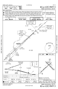
IAC chart of KHUF
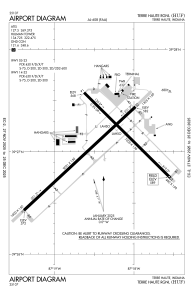
 ADC chart of KHUF
 Satellite view of KHUF
ADC chart of KHUF
Satellite view of KHUF
Sorry, we have no imagery here.
Sorry, we have no imagery here.
Sorry, we have no imagery here.
Sorry, we have no imagery here.
Sorry, we have no imagery here.
Sorry, we have no imagery here.


KHUF - Terre Haute Rgnl
Located in Terre Haute, United States
ICAO - HUF, IATA - HUF
Data provided by AirmateGeneral information
Coordinates: N39°27'2" W87°18'25"
Elevation is 589 feet MSL.
Magnetic variation is -02° East View others Airports in Indiana
Operational data
Special qualification required
Current time UTC:
Current local time:
Weather
METAR: KHUF 301304Z 27005KT 6SM -RA BR OVC060 16/15 A2987 RMK AO2 P0000 T01560150
TAF: KHUF 301306Z 3013/3112 28006KT 5SM BR SCT040 OVC060 TEMPO 3013/3014 4SM -SHRA FM301400 31006KT P6SM BKN080 FM301700 30011G17KT P6SM SCT120 FM310000 28006KT P6SM BKN100
Communications frequencies: [VIEW]
Runways:
| RWY identifier | QFU | Length (ft) | Width (ft) | Surface | LDA (ft) |
| 05 | 47° | 9021 | 150 | ASPH | 9020 |
| 23 | 227° | 9021 | 150 | ASPH | 9020 |
| 14 | 135° | 7200 | 150 | OTHER | 7200 |
| 32 | 315° | 7200 | 150 | OTHER | 7200 |
Airport contact information
Address: Terre Haute United States
Other aviation service providers
Flight schools

Satellite view of KHUF
Sorry, we have no imagery here.
Sorry, we have no imagery here.
Sorry, we have no imagery here.
Sorry, we have no imagery here.
Sorry, we have no imagery here.
Sorry, we have no imagery here.