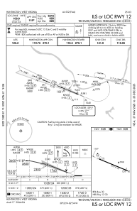
IAC chart of KHTS
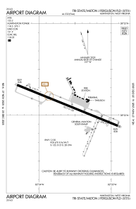
 ADC chart of KHTS
 Satellite view of KHTS

ADC chart of KHTS
Satellite view of KHTS
Sorry, we have no imagery here.
Sorry, we have no imagery here.
Sorry, we have no imagery here.
Sorry, we have no imagery here.
Sorry, we have no imagery here.
Sorry, we have no imagery here.


KHTS - Tri-State/Milton J Ferguson Fld
Located in Huntington, United States
ICAO - HTS, IATA - HTS
Data provided by AirmateGeneral information
Coordinates: N38°22'7" W82°33'37"
Elevation is 828 feet MSL.
Magnetic variation is -06° East View others Airports in West Virginia
Operational data
Special qualification required
Current time UTC:
Current local time:
Weather
METAR: KHTS 180651Z 00000KT 10SM CLR 02/M03 A3020 RMK AO2 SLP227 T00171033
TAF: KHTS 180521Z 1806/1906 VRB03KT P6SM SKC FM181400 19007KT P6SM SKC FM181700 21008G14KT P6SM SKC FM190000 17004KT P6SM SKC
Communications frequencies: [VIEW]
Runways:
| RWY identifier | QFU | Length (ft) | Width (ft) | Surface | LDA (ft) |
| 12 | 112° | 7017 | 150 | ASPH | 6516 |
| 30 | 292° | 7017 | 150 | ASPH | 6516 |
Airport contact information
Address: Huntington United States
Satellite view of KHTS
Sorry, we have no imagery here.
Sorry, we have no imagery here.
Sorry, we have no imagery here.
Sorry, we have no imagery here.
Sorry, we have no imagery here.
Sorry, we have no imagery here.