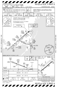
IAC chart of KHST
 ADC chart of KHST
 Satellite view of KHST
ADC chart of KHST
Satellite view of KHST
Sorry, we have no imagery here.
Sorry, we have no imagery here.
Sorry, we have no imagery here.
Sorry, we have no imagery here.
Sorry, we have no imagery here.
Sorry, we have no imagery here.


KHST - Homestead Arb
Located in Homestead, United States
ICAO - HST, IATA - HST
Data provided by AirmateGeneral information
Coordinates: N25°29'19" W80°23'1"
Elevation is 5 feet MSL.
Magnetic variation is -06° East View others Airports in Florida
Operational data
Special qualification required
Current time UTC:
Current local time:
Weather
METAR: KHST 092001Z AUTO 30011G16KT 10SM CLR 27/11 A2994 RMK AO2 WSHFT 1959 SLP142
TAF: TAF KHST 091900Z 0919/1101 33012G18KT 9999 SCT035 BKN090 QNH2994INS BECMG 0922/0923 33009KT 9999 SCT022 SCT040 QNH3000INS BECMG 1013/1014 35009KT 9999 BKN025 QNH3003INS BECMG 1017/1018 03010KT 9999 VCSH SCT035 BKN050 QNH2997INS BECMG 1022/1023 VRB06KT 9999 NSW SCT025 QNH3000INS TX26/0919Z TN19/1011Z
Communications frequencies: [VIEW]
Runways:
| RWY identifier | QFU | Length (ft) | Width (ft) | Surface | LDA (ft) |
| 06 | 0° | 11202 | 300 | CONC | |
| 24 | 0° | 11202 | 300 | CONC |
Airport contact information
Address: Homestead United States
Satellite view of KHST
Sorry, we have no imagery here.
Sorry, we have no imagery here.
Sorry, we have no imagery here.
Sorry, we have no imagery here.
Sorry, we have no imagery here.
Sorry, we have no imagery here.