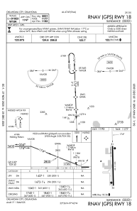
IAC chart of KHSD
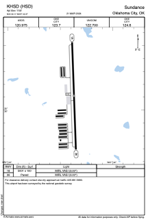
 ADC chart of KHSD
 Satellite view of KHSD
ADC chart of KHSD
Satellite view of KHSD
Sorry, we have no imagery here.
Sorry, we have no imagery here.
Sorry, we have no imagery here.
Sorry, we have no imagery here.
Sorry, we have no imagery here.
Sorry, we have no imagery here.


KHSD - Sundance
Located in Oklahoma City, United States
ICAO - HSD, IATA -
Data provided by AirmateGeneral information
Coordinates: N35°36'7" W97°42'22"
Elevation is 1192 feet MSL.
Magnetic variation is 04° East View others Airports in Oklahoma
Operational data
Special qualification required
Current time UTC:
Current local time:
Weather
METAR: KHSD 301950Z AUTO 32010G15KT 10SM 12/05 A2988 RMK A01
Communications frequencies: [VIEW]
Runways:
| RWY identifier | QFU | Length (ft) | Width (ft) | Surface | LDA (ft) |
| 18 | 178° | 5001 | 100 | CONC | |
| 36 | 358° | 5001 | 100 | CONC |
Airport contact information
Address: Oklahoma City United States
Other aviation service providers
Flight schools

Satellite view of KHSD
Sorry, we have no imagery here.
Sorry, we have no imagery here.
Sorry, we have no imagery here.
Sorry, we have no imagery here.
Sorry, we have no imagery here.
Sorry, we have no imagery here.