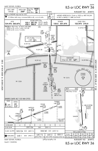
IAC chart of KHRT
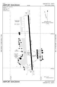
 ADC chart of KHRT
 Satellite view of KHRT
ADC chart of KHRT
Satellite view of KHRT
Sorry, we have no imagery here.
Sorry, we have no imagery here.
Sorry, we have no imagery here.
Sorry, we have no imagery here.
Sorry, we have no imagery here.
Sorry, we have no imagery here.


KHRT - Hurlburt Fld
Located in Mary Esther, United States
ICAO - HRT, IATA -
Data provided by AirmateGeneral information
Coordinates: N30°25'44" W86°41'20"
Elevation is 36 feet MSL.
Magnetic variation is -03° East View others Airports in Florida
Operational data
Special qualification required
Current time UTC:
Current local time:
Weather
METAR: KHRT 200355Z 16009KT 10SM CLR 26/22 A2990 RMK AO2A SLP123 T02600220 $
TAF: TAF KHRT 200200Z 2002/2108 16009KT 9999 SCT200 QNH2990INS BECMG 2013/2014 20012KT 9999 BKN030 QNH2992INS BECMG 2021/2022 23012G18KT 9999 SCT050 QNH2989INS BECMG 2103/2104 26012KT 9999 BKN030 QNH2988INS TX29/2018Z TN25/2002Z
Communications frequencies: [VIEW]
Runways:
| RWY identifier | QFU | Length (ft) | Width (ft) | Surface | LDA (ft) |
| 18 | 176° | 9600 | 150 | CONC | |
| 36 | 356° | 9600 | 150 | CONC |
Airport contact information
Address: Mary Esther United States
Satellite view of KHRT
Sorry, we have no imagery here.
Sorry, we have no imagery here.
Sorry, we have no imagery here.
Sorry, we have no imagery here.
Sorry, we have no imagery here.
Sorry, we have no imagery here.