IAC chart of KHOU
 ADC chart of KHOU
 Satellite view of KHOU
ADC chart of KHOU
Satellite view of KHOU
Sorry, we have no imagery here.
Sorry, we have no imagery here.
Sorry, we have no imagery here.
Sorry, we have no imagery here.
Sorry, we have no imagery here.
Sorry, we have no imagery here.


KHOU - William P Hobby
Located in Houston, United States
ICAO - HOU, IATA - HOU
Data provided by AirmateGeneral information
Coordinates: N29°38'45" W95°16'38"
Elevation is 46 feet MSL.
Magnetic variation is 03° East View others Airports in Texas
Operational data
Special qualification required
Current time UTC:
Current local time:
Weather
METAR: KHOU 281153Z 16009KT 10SM OVC100 20/16 A2994 RMK AO2 RAB19E32 SLP144 P0000 60009 70035 T02000161 10217 20189 58002 $
Communications frequencies: [VIEW]
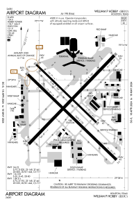
Runways:
| RWY identifier | QFU | Length (ft) | Width (ft) | Surface | LDA (ft) |
| 04 | 44° | 7602 | 150 | CONC | 7602 |
| 22 | 224° | 7602 | 150 | CONC | 7602 |
| 13L | 134° | 5148 | 100 | CONC | 5148 |
| 31R | 314° | 5148 | 100 | CONC | 5148 |
| 13R | 134° | 7602 | 150 | ASPH | 6568 |
| 31L | 314° | 7602 | 150 | ASPH | 7602 |
Airport contact information
Address: Houston United States

Satellite view of KHOU
Sorry, we have no imagery here.
Sorry, we have no imagery here.
Sorry, we have no imagery here.
Sorry, we have no imagery here.
Sorry, we have no imagery here.
Sorry, we have no imagery here.