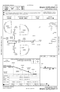
IAC chart of KHNB
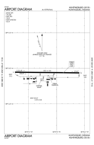
 ADC chart of KHNB
 Satellite view of KHNB
ADC chart of KHNB
Satellite view of KHNB
Sorry, we have no imagery here.
Sorry, we have no imagery here.
Sorry, we have no imagery here.
Sorry, we have no imagery here.
Sorry, we have no imagery here.
Sorry, we have no imagery here.


KHNB - Huntingburg
Located in Huntingburg, United States
ICAO - HNB, IATA - HNB
Data provided by AirmateGeneral information
Coordinates: N38°14'56" W86°57'10"
Elevation is 529 feet MSL.
Magnetic variation is -04° East View others Airports in Indiana
Operational data
Special qualification required
Current time UTC:
Current local time:
Weather
METAR: KHNB 131156Z AUTO 13004KT 10SM CLR 07/04 A3011 RMK AO2 SLP197 T00720039 10078 20061 53003
TAF: KHNB 131120Z 1312/1412 15004KT P6SM BKN150 FM131500 17013G20KT P6SM BKN250 FM131700 17015G25KT P6SM SCT250 FM140200 18012KT P6SM BKN250
Communications frequencies: [VIEW]
Runways:
| RWY identifier | QFU | Length (ft) | Width (ft) | Surface | LDA (ft) |
| 09 | 91° | 5501 | 100 | ASPH | |
| 27 | 271° | 5501 | 100 | ASPH |
Airport contact information
Address: Huntingburg United States
Other aviation service providers
Flight schools

Satellite view of KHNB
Sorry, we have no imagery here.
Sorry, we have no imagery here.
Sorry, we have no imagery here.
Sorry, we have no imagery here.
Sorry, we have no imagery here.
Sorry, we have no imagery here.