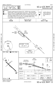
IAC chart of KHIB
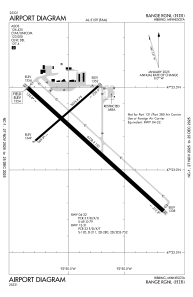
 ADC chart of KHIB
 Satellite view of KHIB
ADC chart of KHIB
Satellite view of KHIB
Sorry, we have no imagery here.
Sorry, we have no imagery here.
Sorry, we have no imagery here.
Sorry, we have no imagery here.
Sorry, we have no imagery here.
Sorry, we have no imagery here.


KHIB - Range Rgnl
Located in Hibbing, United States
ICAO - HIB, IATA - HIB
Data provided by AirmateGeneral information
Coordinates: N47°23'12" W92°50'20"
Elevation is 1353 feet MSL.
Magnetic variation is 02° East View others Airports in Minnesota
Operational data
Special qualification required
Current time UTC:
Current local time:
Weather
METAR: KHIB 202153Z AUTO 09014G24KT 10SM CLR 10/M09 A2986 RMK AO2 PK WND 10027/2135 SLP120 T01001094
TAF: KHIB 201720Z 2018/2118 08017G31KT P6SM BKN120 FM210000 10015G30KT P6SM VCSH BKN060 FM210100 09014G31KT 6SM -SHRA SCT010 OVC045 WS020/10040KT FM211200 09011G21KT P6SM VCSH SCT010 BKN045 FM211500 09013G21KT P6SM BKN027
Communications frequencies: [VIEW]
Runways:
| RWY identifier | QFU | Length (ft) | Width (ft) | Surface | LDA (ft) |
| 04 | 49° | 3075 | 75 | ASPH | 3075 |
| 22 | 229° | 3075 | 75 | ASPH | 3075 |
| 13 | 132° | 6758 | 150 | ASPH | 6758 |
| 31 | 312° | 6758 | 150 | ASPH | 6758 |
Airport contact information
Address: Hibbing United States
Satellite view of KHIB
Sorry, we have no imagery here.
Sorry, we have no imagery here.
Sorry, we have no imagery here.
Sorry, we have no imagery here.
Sorry, we have no imagery here.
Sorry, we have no imagery here.