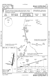
IAC chart of KHFD
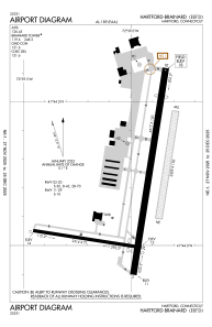
 ADC chart of KHFD
 Satellite view of KHFD
ADC chart of KHFD
Satellite view of KHFD
Sorry, we have no imagery here.
Sorry, we have no imagery here.
Sorry, we have no imagery here.
Sorry, we have no imagery here.
Sorry, we have no imagery here.
Sorry, we have no imagery here.


KHFD - Hartford-Brainard
Located in Hartford, United States
ICAO - HFD, IATA -
Data provided by AirmateGeneral information
Coordinates: N41°44'12" W72°38'58"
Elevation is 18 feet MSL.
Magnetic variation is -15° East View others Airports in Connecticut
Operational data
Special qualification required
Current time UTC:
Current local time:
Weather
METAR: KHFD 191453Z 34013G21KT 10SM SCT040 15/06 A2972 RMK AO2 PK WND 02029/1355 SLP065 T01500056 58003
Communications frequencies: [VIEW]
Runways:
| RWY identifier | QFU | Length (ft) | Width (ft) | Surface | LDA (ft) |
| 02 | 9° | 4417 | 150 | ASPH | |
| 20 | 189° | 4417 | 150 | ASPH | |
| 11 | 99° | 2314 | 71 | ASPH | |
| 29 | 279° | 2314 | 71 | ASPH | |
| H1 | 0° | 0 | 0 | UNK | |
| H2 | 0° | 0 | 0 | UNK | |
| NE | 0° | 2309 | 150 | GRASS | |
| SW | 0° | 2309 | 150 | GRASS |
Airport contact information
Address: Hartford United States
Other aviation service providers
Flight schools

Connecticut Flight Club, Inc.
Connecticut Flight Club, Inc.
connecticuitflightclub@gmail.com+1(860)888-3243
Atp Flight School (800-All-Atps)
Atp Flight School (800-All-Atps)
info@atpflightschool.com+1(800)255-2877
Satellite view of KHFD
Sorry, we have no imagery here.
Sorry, we have no imagery here.
Sorry, we have no imagery here.
Sorry, we have no imagery here.
Sorry, we have no imagery here.
Sorry, we have no imagery here.