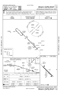
IAC chart of KHEI
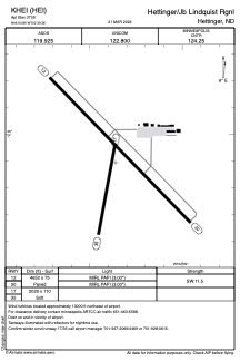
 ADC chart of KHEI
 Satellite view of KHEI
ADC chart of KHEI
Satellite view of KHEI
Sorry, we have no imagery here.
Sorry, we have no imagery here.
Sorry, we have no imagery here.
Sorry, we have no imagery here.
Sorry, we have no imagery here.
Sorry, we have no imagery here.


KHEI - Hettinger/Jb Lindquist Rgnl
Located in Hettinger, United States
ICAO - HEI, IATA -
Data provided by AirmateGeneral information
Coordinates: N46°0'54" W102°39'22"
Elevation is 2705 feet MSL.
Magnetic variation is 08° East View others Airports in North Dakota
Operational data
Special qualification required
Current time UTC:
Current local time:
Weather
METAR: KHEI 201553Z AUTO 13012KT 10SM CLR M23/M27 A3034 RMK AO2 SLP365 T12281267
Communications frequencies: [VIEW]
Runways:
| RWY identifier | QFU | Length (ft) | Width (ft) | Surface | LDA (ft) |
| 12 | 136° | 4652 | 75 | ASPH | |
| 30 | 316° | 4652 | 75 | ASPH | |
| 17 | 190° | 2020 | 110 | GRASS | |
| 35 | 10° | 2020 | 110 | GRASS |
Airport contact information
Address: Hettinger United States
Satellite view of KHEI
Sorry, we have no imagery here.
Sorry, we have no imagery here.
Sorry, we have no imagery here.
Sorry, we have no imagery here.
Sorry, we have no imagery here.
Sorry, we have no imagery here.