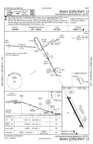
IAC chart of KHCD
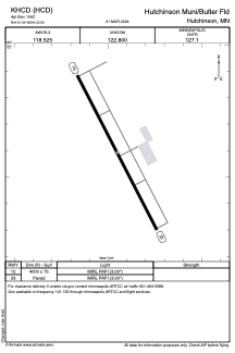
 ADC chart of KHCD
 Satellite view of KHCD
ADC chart of KHCD
Satellite view of KHCD
Sorry, we have no imagery here.
Sorry, we have no imagery here.
Sorry, we have no imagery here.
Sorry, we have no imagery here.
Sorry, we have no imagery here.
Sorry, we have no imagery here.


KHCD - Hutchinson Muni/Butler Fld
Located in Hutchinson, United States
ICAO - HCD, IATA -
Data provided by AirmateGeneral information
Coordinates: N44°51'36" W94°22'57"
Elevation is 1062 feet MSL.
Magnetic variation is 04° East View others Airports in Minnesota
Operational data
Special qualification required
Current time UTC:
Current local time:
Weather
METAR: KHCD 222115Z AUTO 13016KT 10SM CLR 06/M09 A2985 RMK AO2 T00641090
Communications frequencies: [VIEW]
Runways:
| RWY identifier | QFU | Length (ft) | Width (ft) | Surface | LDA (ft) |
| 15 | 152° | 4000 | 75 | ASPH | |
| 33 | 332° | 4000 | 75 | ASPH |
Airport contact information
Address: Hutchinson United States
Satellite view of KHCD
Sorry, we have no imagery here.
Sorry, we have no imagery here.
Sorry, we have no imagery here.
Sorry, we have no imagery here.
Sorry, we have no imagery here.
Sorry, we have no imagery here.