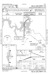
IAC chart of KGYI
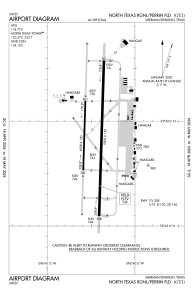
 ADC chart of KGYI
 Satellite view of KGYI

ADC chart of KGYI
Satellite view of KGYI
Sorry, we have no imagery here.
Sorry, we have no imagery here.
Sorry, we have no imagery here.
Sorry, we have no imagery here.
Sorry, we have no imagery here.
Sorry, we have no imagery here.


KGYI - North Texas Rgnl/Perrin Fld
Located in Sherman/Denison, United States
ICAO - GYI, IATA -
Data provided by AirmateGeneral information
Coordinates: N33°42'51" W96°40'27"
Elevation is 749 feet MSL.
Magnetic variation is 03° East View others Airports in Texas
Operational data
Special qualification required
Current time UTC:
Current local time:
Weather
METAR: KGYI 231650Z 00000KT 10SM OVC045 11/M02 A3019
Communications frequencies: [VIEW]
Runways:
| RWY identifier | QFU | Length (ft) | Width (ft) | Surface | LDA (ft) |
| 18L | 182° | 9000 | 150 | OTHER | |
| 36R | 2° | 9000 | 150 | OTHER | |
| 18R | 182° | 4008 | 100 | OTHER | |
| 36L | 2° | 4008 | 100 | OTHER |
Airport contact information
Address: Sherman/Denison United States
Satellite view of KGYI
Sorry, we have no imagery here.
Sorry, we have no imagery here.
Sorry, we have no imagery here.
Sorry, we have no imagery here.
Sorry, we have no imagery here.
Sorry, we have no imagery here.