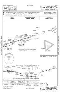
IAC chart of KGUP
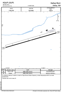
 ADC chart of KGUP
 Satellite view of KGUP
ADC chart of KGUP
Satellite view of KGUP
Sorry, we have no imagery here.
Sorry, we have no imagery here.
Sorry, we have no imagery here.
Sorry, we have no imagery here.
Sorry, we have no imagery here.
Sorry, we have no imagery here.


KGUP - Gallup Muni
Located in Gallup, United States
ICAO - GUP, IATA - GUP
Data provided by AirmateGeneral information
Coordinates: N35°30'40" W108°47'22"
Elevation is 6472 feet MSL.
Magnetic variation is 12° East View others Airports in New Mexico
Operational data
Special qualification required
Current time UTC:
Current local time:
Weather
METAR: KGUP 211053Z AUTO 09003KT 10SM CLR M10/M16 A3013 RMK AO2 SLP202 T11001161
TAF: KGUP 210533Z 2106/2206 VRB04KT P6SM SKC FM212100 32007KT P6SM SCT150 FM220100 VRB03KT P6SM FEW150
Communications frequencies: [VIEW]
Runways:
| RWY identifier | QFU | Length (ft) | Width (ft) | Surface | LDA (ft) |
| 06 | 74° | 7312 | 100 | ASPH | |
| 24 | 254° | 7312 | 100 | ASPH |
Airport contact information
Address: Gallup United States
Satellite view of KGUP
Sorry, we have no imagery here.
Sorry, we have no imagery here.
Sorry, we have no imagery here.
Sorry, we have no imagery here.
Sorry, we have no imagery here.
Sorry, we have no imagery here.