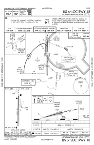
IAC chart of KGTR
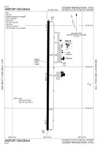
 ADC chart of KGTR
 Satellite view of KGTR
ADC chart of KGTR
Satellite view of KGTR
Sorry, we have no imagery here.
Sorry, we have no imagery here.
Sorry, we have no imagery here.
Sorry, we have no imagery here.
Sorry, we have no imagery here.
Sorry, we have no imagery here.


KGTR - Golden Triangle Rgnl
Located in Columbus/W Point/Starkville, United States
ICAO - GTR, IATA - GTR
Data provided by AirmateGeneral information
Coordinates: N33°26'54" W88°35'29"
Elevation is 264 feet MSL.
Magnetic variation is -02° East View others Airports in Mississippi
Operational data
Special qualification required
Current time UTC:
Current local time:
Weather
METAR: KGTR 301956Z 17008KT 10SM FEW033 27/20 A2986 RMK AO2 SLP111 T02720200
TAF: KGTR 301740Z 3018/3118 18011KT P6SM OVC019 FM302000 18011G20KT P6SM BKN045 FM310800 18008KT 4SM TSRA OVC015CB TEMPO 3108/3110 27020G40KT 1SM +TSRA BR OVC025CB FM311100 27007KT 5SM -TSRA BR OVC008CB FM311200 25005KT 6SM -RA BR OVC007
Communications frequencies: [VIEW]
Runways:
| RWY identifier | QFU | Length (ft) | Width (ft) | Surface | LDA (ft) |
| 18 | 180° | 8003 | 150 | ASPH | |
| 36 | 0° | 8003 | 150 | ASPH |
Airport contact information
Address: Columbus/W Point/Starkville United States
Other aviation service providers
Flight schools

Satellite view of KGTR
Sorry, we have no imagery here.
Sorry, we have no imagery here.
Sorry, we have no imagery here.
Sorry, we have no imagery here.
Sorry, we have no imagery here.
Sorry, we have no imagery here.