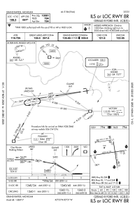
IAC chart of KGRR
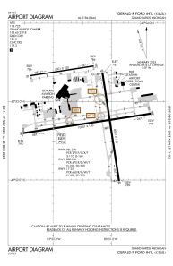
 ADC chart of KGRR
 Satellite view of KGRR
ADC chart of KGRR
Satellite view of KGRR
Sorry, we have no imagery here.
Sorry, we have no imagery here.
Sorry, we have no imagery here.
Sorry, we have no imagery here.
Sorry, we have no imagery here.
Sorry, we have no imagery here.


KGRR - Gerald R Ford Intl
Located in Grand Rapids, United States
ICAO - GRR, IATA - GRR
Data provided by AirmateGeneral information
Coordinates: N42°52'51" W85°31'22"
Elevation is 793 feet MSL.
Magnetic variation is -06° East View others Airports in Michigan
Operational data
Special qualification required
Current time UTC:
Current local time:
Weather
METAR: KGRR 210853Z AUTO 09012KT 6SM -RA BR OVC009 08/07 A2970 RMK AO2 RAB03 CIG 007V013 SLP059 P0000 60005 T00830072 58013 $
TAF: KGRR 210826Z 2108/2206 08012KT P6SM -RA OVC009 FM210900 07016G24KT 4SM -SHRA BR OVC008 FM211200 07013G21KT 3SM -SHRA BR OVC004
Communications frequencies: [VIEW]
Runways:
| RWY identifier | QFU | Length (ft) | Width (ft) | Surface | LDA (ft) |
| 08L | 81° | 5001 | 100 | ASPH | 5001 |
| 26R | 261° | 5001 | 100 | ASPH | 5001 |
| 08R | 81° | 10001 | 150 | CONC | 10001 |
| 26L | 261° | 10001 | 150 | CONC | 10001 |
| 17 | 171° | 8501 | 150 | CONC | 8501 |
| 35 | 351° | 8501 | 150 | CONC | 8501 |
Airport contact information
Address: Grand Rapids United States
Other aviation service providers
Repair station

Satellite view of KGRR
Sorry, we have no imagery here.
Sorry, we have no imagery here.
Sorry, we have no imagery here.
Sorry, we have no imagery here.
Sorry, we have no imagery here.
Sorry, we have no imagery here.