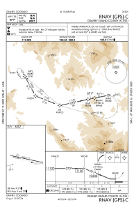
IAC chart of KGNB
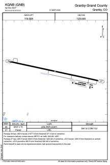
 ADC chart of KGNB
 Satellite view of KGNB
ADC chart of KGNB
Satellite view of KGNB
Sorry, we have no imagery here.
Sorry, we have no imagery here.
Sorry, we have no imagery here.
Sorry, we have no imagery here.
Sorry, we have no imagery here.
Sorry, we have no imagery here.


KGNB - Granby-Grand County
Located in Granby, United States
ICAO - GNB, IATA -
Data provided by AirmateGeneral information
Coordinates: N40°5'24" W105°54'60"
Elevation is 8207 feet MSL.
Magnetic variation is 08° East View others Airports in Colorado
Operational data
Special qualification required
Current time UTC:
Current local time:
Weather
METAR: KGNB 310835Z AUTO 12004KT 10SM CLR 07/04 A3052 RMK AO2 T00680041
Communications frequencies: [VIEW]
Runways:
| RWY identifier | QFU | Length (ft) | Width (ft) | Surface | LDA (ft) |
| 09 | 102° | 5001 | 75 | ASPH | |
| 27 | 282° | 5001 | 75 | ASPH |
Airport contact information
Address: Granby United States
Satellite view of KGNB
Sorry, we have no imagery here.
Sorry, we have no imagery here.
Sorry, we have no imagery here.
Sorry, we have no imagery here.
Sorry, we have no imagery here.
Sorry, we have no imagery here.