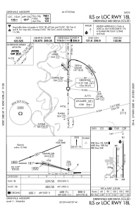
IAC chart of KGLH
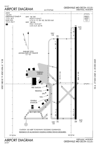
 ADC chart of KGLH
 Satellite view of KGLH

ADC chart of KGLH
Satellite view of KGLH
Sorry, we have no imagery here.
Sorry, we have no imagery here.
Sorry, we have no imagery here.
Sorry, we have no imagery here.
Sorry, we have no imagery here.
Sorry, we have no imagery here.


KGLH - Greenville Mid-Delta
Located in Greenville, United States
ICAO - GLH, IATA - GLH
Data provided by AirmateGeneral information
Coordinates: N33°29'7" W90°59'4"
Elevation is 130 feet MSL.
Magnetic variation is -01° East View others Airports in Mississippi
Operational data
Special qualification required
Current time UTC:
Current local time:
Weather
METAR: KGLH 171853Z 19009KT 10SM CLR 18/03 A3027 RMK AO2 SLP258 T01830033
TAF: KGLH 171720Z 1718/1818 20006KT P6SM SKC FM172000 20008KT P6SM FEW250 FM180200 17008KT P6SM FEW250
Communications frequencies: [VIEW]
Runways:
| RWY identifier | QFU | Length (ft) | Width (ft) | Surface | LDA (ft) |
| 18L | 180° | 8001 | 150 | ASPH | 7981 |
| 36R | 0° | 8001 | 150 | ASPH | 8001 |
| 18R | 180° | 7019 | 150 | OTHER | |
| 36L | 360° | 7019 | 150 | OTHER |
Airport contact information
Address: Greenville United States
Satellite view of KGLH
Sorry, we have no imagery here.
Sorry, we have no imagery here.
Sorry, we have no imagery here.
Sorry, we have no imagery here.
Sorry, we have no imagery here.
Sorry, we have no imagery here.