


KGJT - Grand Junction Rgnl
Located in Grand Junction, United States
ICAO - GJT, IATA - GJT
Data provided by AirmateGeneral information
Coordinates: N39°7'17" W108°31'32"
Elevation is 4861 feet MSL.
Magnetic variation is 09° East View others Airports in Colorado
Operational data
Special qualification required
Current time UTC:
Current local time:
Weather
METAR: KGJT 241453Z 11006KT 10SM CLR 16/04 A3018 RMK AO2 SLP168 T01560039 51017
TAF: KGJT 241124Z 2412/2512 10010KT P6SM SCT250 FM241400 13007KT P6SM SCT250 FM241700 VRB04KT P6SM FEW250 FM242100 28006KT P6SM FEW120 FM250200 VRB04KT P6SM FEW250 FM250800 11007KT P6SM FEW250
Communications frequencies: [VIEW]
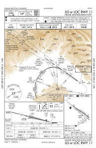
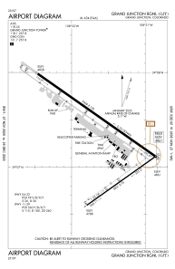
Runways:
| RWY identifier | QFU | Length (ft) | Width (ft) | Surface | LDA (ft) |
| 04 | 54° | 5501 | 75 | ASPH | 5501 |
| 22 | 234° | 5501 | 75 | ASPH | 5501 |
| 11 | 125° | 9339 | 150 | ASPH | 9339 |
| 29 | 305° | 9339 | 150 | ASPH | 9339 |
Airport contact information
Address: Grand Junction United States

