IAC chart of KGGE
 ADC chart of KGGE
 Satellite view of KGGE
ADC chart of KGGE
Satellite view of KGGE
Sorry, we have no imagery here.
Sorry, we have no imagery here.
Sorry, we have no imagery here.
Sorry, we have no imagery here.
Sorry, we have no imagery here.
Sorry, we have no imagery here.


KGGE - Georgetown County
Located in Georgetown, United States
ICAO - GGE, IATA - GGE
Data provided by AirmateGeneral information
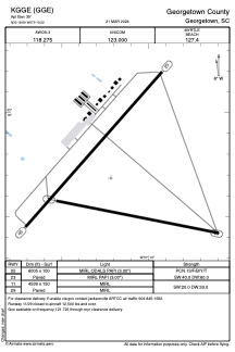
Coordinates: N33°18'41" W79°19'13"
Elevation is 39 feet MSL.
Magnetic variation is -08° East View others Airports in South Carolina
Operational data
Special qualification required
Current time UTC:
Current local time:
Weather
METAR: KGGE 301835Z AUTO 11011KT 10SM SCT033 BKN048 BKN060 23/18 A3010 RMK AO2
Communications frequencies: [VIEW]
Runways:
| RWY identifier | QFU | Length (ft) | Width (ft) | Surface | LDA (ft) |
| 05 | 41° | 6005 | 100 | ASPH | |
| 23 | 221° | 6005 | 100 | ASPH | |
| 11 | 101° | 4539 | 150 | ASPH | |
| 29 | 281° | 4539 | 150 | ASPH |
Airport contact information
Address: Georgetown United States
Satellite view of KGGE
Sorry, we have no imagery here.
Sorry, we have no imagery here.
Sorry, we have no imagery here.
Sorry, we have no imagery here.
Sorry, we have no imagery here.
Sorry, we have no imagery here.