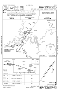
IAC chart of KFWB
 Satellite view of KFWB
Satellite view of KFWB
Sorry, we have no imagery here.
Sorry, we have no imagery here.
Sorry, we have no imagery here.
Sorry, we have no imagery here.
Sorry, we have no imagery here.
Sorry, we have no imagery here.


KFWB - Branson West Muni/Emerson Fld
Located in Branson West, United States
ICAO - FWB, IATA -
Data provided by AirmateGeneral information
Coordinates: N36°41'55" W93°24'8"
Elevation is 1348 feet MSL.
Magnetic variation is 02° East View others Airports in Missouri
Operational data
Special qualification required
Current time UTC:
Current local time:
Weather
METAR: KFWB 281835Z AUTO 17014G27KT 130V210 10SM FEW039 FEW095 SCT120 20/11 A3000 RMK AO2 TSNO
Communications frequencies: [VIEW]
Runways:
| RWY identifier | QFU | Length (ft) | Width (ft) | Surface | LDA (ft) |
| 03 | 36° | 5002 | 75 | CONC | |
| 21 | 216° | 5002 | 75 | CONC |
Airport contact information
Address: Branson West United States
Other aviation service providers
Flight schools

Satellite view of KFWB
Sorry, we have no imagery here.
Sorry, we have no imagery here.
Sorry, we have no imagery here.
Sorry, we have no imagery here.
Sorry, we have no imagery here.
Sorry, we have no imagery here.