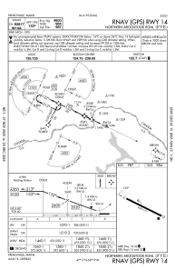
IAC chart of KFVE
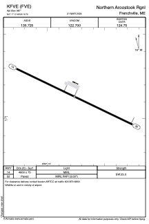
 ADC chart of KFVE
 Satellite view of KFVE
ADC chart of KFVE
Satellite view of KFVE
Sorry, we have no imagery here.
Sorry, we have no imagery here.
Sorry, we have no imagery here.
Sorry, we have no imagery here.
Sorry, we have no imagery here.


KFVE - Northern Aroostook Rgnl
Located in Frenchville, United States
ICAO - FVE, IATA - WFK
Data provided by AirmateGeneral information
Coordinates: N47°17'8" W68°18'46"
Elevation is 987 feet MSL.
Magnetic variation is -18° East View others Airports in Maine
Operational data
Special qualification required
Current time UTC:
Current local time:
Weather
METAR: KFVE 100853Z AUTO 24010KT 10SM CLR M04/M12 A3010 RMK AO2 SLP204 T10441117 53001
TAF: KFVE 100536Z 1006/1106 24010G18KT P6SM SCT200 FM101500 26010G18KT P6SM SCT200 FM110000 20008KT P6SM BKN200
Communications frequencies: [VIEW]
Runways:
| RWY identifier | QFU | Length (ft) | Width (ft) | Surface | LDA (ft) |
| 14 | 116° | 4600 | 75 | ASPH | |
| 32 | 296° | 4600 | 75 | ASPH |
Airport contact information
Address: Frenchville United States
Other aviation service providers
Flight schools

Satellite view of KFVE
Sorry, we have no imagery here.
Sorry, we have no imagery here.
Sorry, we have no imagery here.
Sorry, we have no imagery here.
Sorry, we have no imagery here.