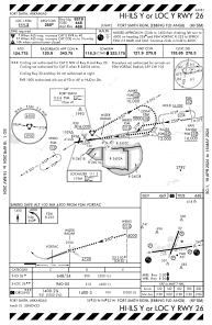
IAC chart of KFSM
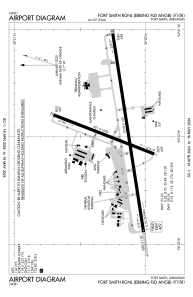
 ADC chart of KFSM
 Satellite view of KFSM
ADC chart of KFSM
Satellite view of KFSM
Sorry, we have no imagery here.
Sorry, we have no imagery here.
Sorry, we have no imagery here.
Sorry, we have no imagery here.
Sorry, we have no imagery here.
Sorry, we have no imagery here.


KFSM - Fort Smith Rgnl
Located in Fort Smith, United States
ICAO - FSM, IATA - FSM
Data provided by AirmateGeneral information
Coordinates: N35°20'12" W94°21'58"
Elevation is 469 feet MSL.
Magnetic variation is 01° East View others Airports in Arkansas
Operational data
Special qualification required
Current time UTC:
Current local time:
Weather
METAR: KFSM 090953Z AUTO 06007KT 10SM CLR 08/05 A3007 RMK AO2 SLP180 T00830050
TAF: KFSM 090520Z 0906/1006 07005KT P6SM SCT250 FM091600 20013G21KT P6SM SCT250 FM100100 VRB03KT P6SM SCT250
Communications frequencies: [VIEW]
Runways:
| RWY identifier | QFU | Length (ft) | Width (ft) | Surface | LDA (ft) |
| 02 | 21° | 5001 | 150 | ASPH | 5001 |
| 20 | 201° | 5001 | 150 | ASPH | 5001 |
| 08 | 81° | 9318 | 150 | ASPH | |
| 26 | 261° | 9318 | 150 | ASPH |
Airport contact information
Address: Fort Smith United States
Other aviation service providers
Repair station

Satellite view of KFSM
Sorry, we have no imagery here.
Sorry, we have no imagery here.
Sorry, we have no imagery here.
Sorry, we have no imagery here.
Sorry, we have no imagery here.
Sorry, we have no imagery here.