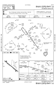
IAC chart of KFIT
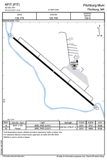
 ADC chart of KFIT
 Satellite view of KFIT
ADC chart of KFIT
Satellite view of KFIT
Sorry, we have no imagery here.
Sorry, we have no imagery here.
Sorry, we have no imagery here.
Sorry, we have no imagery here.
Sorry, we have no imagery here.
Sorry, we have no imagery here.


KFIT - Fitchburg Muni
Located in Fitchburg, United States
ICAO - FIT, IATA -
Data provided by AirmateGeneral information
Coordinates: N42°33'14" W71°45'33"
Elevation is 344 feet MSL.
Magnetic variation is -15° East View others Airports in Massachusetts
Operational data
Special qualification required
Current time UTC:
Current local time:
Weather
METAR: KFIT 190952Z AUTO 32012G22KT 10SM FEW075 SCT090 BKN120 10/04 A2964 RMK AO2 RAB35E44 SLP038 P0000 T01000044
Communications frequencies: [VIEW]
Runways:
| RWY identifier | QFU | Length (ft) | Width (ft) | Surface | LDA (ft) |
| 14 | 130° | 5001 | 100 | ASPH | 4538 |
| 32 | 310° | 5001 | 100 | ASPH | 4538 |
Airport contact information
Address: Fitchburg United States
Other aviation service providers
Repair station

Flight schools

Satellite view of KFIT
Sorry, we have no imagery here.
Sorry, we have no imagery here.
Sorry, we have no imagery here.
Sorry, we have no imagery here.
Sorry, we have no imagery here.
Sorry, we have no imagery here.