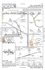
IAC chart of KFHU
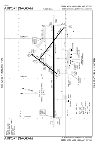
 ADC chart of KFHU
 Satellite view of KFHU
ADC chart of KFHU
Satellite view of KFHU
Sorry, we have no imagery here.
Sorry, we have no imagery here.
Sorry, we have no imagery here.
Sorry, we have no imagery here.
Sorry, we have no imagery here.
Sorry, we have no imagery here.


KFHU - Sierra Vista Muni-Libby Aaf
Located in Fort Huachuca Sierra Vista, United States
ICAO - FHU, IATA - FHU
Data provided by AirmateGeneral information
Coordinates: N31°35'18" W110°20'40"
Elevation is 4719 feet MSL.
Magnetic variation is 10° East View others Airports in Arizona
Operational data
Special qualification required
Current time UTC:
Current local time:
Weather
METAR: KFHU 221055Z AUTO 22005KT 10SM CLR 20/M10 A3008 RMK AO2 SLP108 T02011102
TAF: TAF KFHU 220400Z 2204/2310 VRB06KT 9999 SKC QNH3007INS BECMG 2219/2220 25012G22KT 9999 SKC 510005 QNH3010INS WND VRB06KT AFT 2305 TX35/2221Z TN18/2212Z
Communications frequencies: [VIEW]
Runways:
| RWY identifier | QFU | Length (ft) | Width (ft) | Surface | LDA (ft) |
| 03 | 37° | 4285 | 75 | OTHER | 3032 |
| 21 | 217° | 4285 | 75 | OTHER | 4285 |
| 08 | 90° | 12001 | 150 | CONC | 12001 |
| 26 | 270° | 12001 | 150 | CONC | 12001 |
| 12 | 127° | 5366 | 100 | OTHER | 5366 |
| 30 | 307° | 5366 | 100 | OTHER | 5366 |
| H1 | 0° | 0 | 0 | UNK |
Airport contact information
Address: Fort Huachuca Sierra Vista United States
Satellite view of KFHU
Sorry, we have no imagery here.
Sorry, we have no imagery here.
Sorry, we have no imagery here.
Sorry, we have no imagery here.
Sorry, we have no imagery here.
Sorry, we have no imagery here.