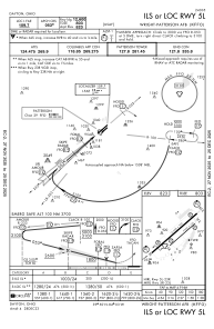
IAC chart of KFFO
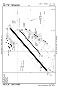
 ADC chart of KFFO
 Satellite view of KFFO

ADC chart of KFFO
Satellite view of KFFO
Sorry, we have no imagery here.
Sorry, we have no imagery here.
Sorry, we have no imagery here.
Sorry, we have no imagery here.
Sorry, we have no imagery here.


KFFO - Wright-Patterson Afb
Located in Dayton, United States
ICAO - FFO, IATA - FFO
Data provided by AirmateGeneral information
Coordinates: N39°49'33" W84°2'46"
Elevation is 823 feet MSL.
Magnetic variation is -04° East View others Airports in Ohio
Operational data
Special qualification required
Current time UTC:
Current local time:
Weather
METAR: KFFO 100055Z AUTO 25003KT 10SM CLR 08/M05 A2996 RMK AO2 SLP153 T00751052
TAF: TAF KFFO 091900Z 0919/1101 26012KT 9999 SKC QNH2982INS WND 23009KT AFT 1000 TEMPO 0919/0923 26012G18KT TX15/0921Z TN01/1011Z
Communications frequencies: [VIEW]
Runways:
| RWY identifier | QFU | Length (ft) | Width (ft) | Surface | LDA (ft) |
| 05L | 0° | 12600 | 300 | OTHER | |
| 23R | 0° | 12600 | 300 | OTHER | |
| 05R | 0° | 7000 | 150 | ASPH | |
| 23L | 0° | 7000 | 150 | ASPH |
Airport contact information
Address: Dayton United States
Satellite view of KFFO
Sorry, we have no imagery here.
Sorry, we have no imagery here.
Sorry, we have no imagery here.
Sorry, we have no imagery here.
Sorry, we have no imagery here.