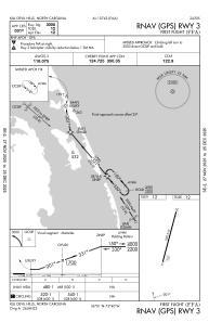
IAC chart of KFFA
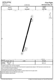
 ADC chart of KFFA
 Satellite view of KFFA
ADC chart of KFFA
Satellite view of KFFA
Sorry, we have no imagery here.
Sorry, we have no imagery here.
Sorry, we have no imagery here.
Sorry, we have no imagery here.
Sorry, we have no imagery here.
Sorry, we have no imagery here.


KFFA - First Flight
Located in Kill Devil Hills, United States
ICAO - FFA, IATA - FFA
Data provided by AirmateGeneral information
Coordinates: N36°1'3" W75°40'18"
Elevation is 11 feet MSL.
Magnetic variation is -11° East View others Airports in North Carolina
Operational data
Special qualification required
Current time UTC:
Current local time:
Weather
METAR: KFFA 221800Z AUTO 27014G22KT 250V310 10SM CLR 24/12 A2977 RMK AO2 T02410115
Communications frequencies: [VIEW]
Runways:
| RWY identifier | QFU | Length (ft) | Width (ft) | Surface | LDA (ft) |
| 03 | 15° | 3000 | 60 | ASPH | |
| 21 | 195° | 3000 | 60 | ASPH |
Airport contact information
Address: Kill Devil Hills United States
Satellite view of KFFA
Sorry, we have no imagery here.
Sorry, we have no imagery here.
Sorry, we have no imagery here.
Sorry, we have no imagery here.
Sorry, we have no imagery here.
Sorry, we have no imagery here.