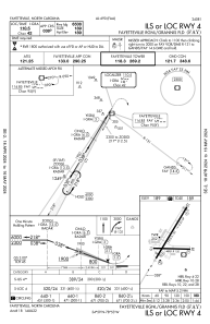
IAC chart of KFAY
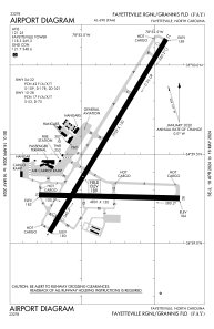
 ADC chart of KFAY
 Satellite view of KFAY
ADC chart of KFAY
Satellite view of KFAY
Sorry, we have no imagery here.
Sorry, we have no imagery here.
Sorry, we have no imagery here.
Sorry, we have no imagery here.
Sorry, we have no imagery here.
Sorry, we have no imagery here.


KFAY - Fayetteville Rgnl/Grannis Fld
Located in Fayetteville, United States
ICAO - FAY, IATA - FAY
Data provided by AirmateGeneral information
Coordinates: N34°59'28" W78°52'49"
Elevation is 189 feet MSL.
Magnetic variation is -07° East View others Airports in North Carolina
Operational data
Special qualification required
Current time UTC:
Current local time:
Communications frequencies: [VIEW]
Runways:
| RWY identifier | QFU | Length (ft) | Width (ft) | Surface | LDA (ft) |
| 04 | 31° | 7709 | 150 | ASPH | 6508 |
| 22 | 211° | 7709 | 150 | ASPH | 6413 |
| 10 | 91° | 4801 | 150 | ASPH | |
| 28 | 271° | 4801 | 150 | ASPH |
Airport contact information
Address: Fayetteville United States
Other aviation service providers
Repair station

Flight schools

All American Aviation Services, Llc
All American Aviation Services, Llc
allamericanaviationservices@gmail.com+1(910)644-8817
Fayetteville Technical Community College
Fayetteville Technical Community College
ceonline@faytechcc.edu+1(910)678-8431
Satellite view of KFAY
Sorry, we have no imagery here.
Sorry, we have no imagery here.
Sorry, we have no imagery here.
Sorry, we have no imagery here.
Sorry, we have no imagery here.
Sorry, we have no imagery here.