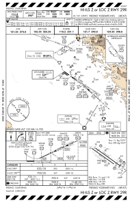
IAC chart of KFAT
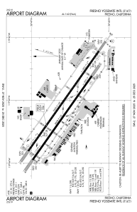
 ADC chart of KFAT
 Satellite view of KFAT
ADC chart of KFAT
Satellite view of KFAT
Sorry, we have no imagery here.
Sorry, we have no imagery here.
Sorry, we have no imagery here.
Sorry, we have no imagery here.
Sorry, we have no imagery here.
Sorry, we have no imagery here.


KFAT - Fresno Yosemite Intl
Located in Fresno, United States
ICAO - FAT, IATA - FAT
Data provided by AirmateGeneral information
Coordinates: N36°46'36" W119°43'8"
Elevation is 335 feet MSL.
Magnetic variation is 13° East View others Airports in California
Operational data
Special qualification required
Current time UTC:
Current local time:
Weather
METAR: KFAT 290653Z 31014G21KT 10SM FEW200 11/05 A3003 RMK AO2 SLP168 T01110050
TAF: KFAT 290520Z 2906/3006 31014G22KT P6SM SCT050 BKN200 FM291200 31009KT P6SM BKN200 FM300000 VRB04KT P6SM OVC200
Communications frequencies: [VIEW]
Runways:
| RWY identifier | QFU | Length (ft) | Width (ft) | Surface | LDA (ft) |
| 11L | 125° | 9539 | 150 | ASPH | 9279 |
| 29R | 305° | 9539 | 150 | ASPH | 9227 |
| 11R | 125° | 8008 | 150 | ASPH | 8008 |
| 29L | 305° | 8008 | 150 | ASPH | 8008 |
Airport contact information
Address: Fresno United States
Other aviation service providers
Repair station

Signature Technicair - Fresno
Signature Technicair - Fresno
rob.wilkinson@technicair.com559-251-3794,ext3
Flight schools

Satellite view of KFAT
Sorry, we have no imagery here.
Sorry, we have no imagery here.
Sorry, we have no imagery here.
Sorry, we have no imagery here.
Sorry, we have no imagery here.
Sorry, we have no imagery here.