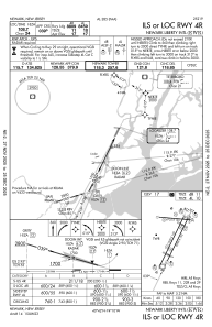
IAC chart of KEWR
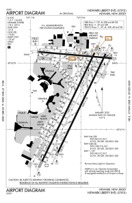
 ADC chart of KEWR
 Satellite view of KEWR
ADC chart of KEWR
Satellite view of KEWR
Sorry, we have no imagery here.
Sorry, we have no imagery here.
Sorry, we have no imagery here.
Sorry, we have no imagery here.
Sorry, we have no imagery here.
Sorry, we have no imagery here.


KEWR - Newark Liberty Intl
Located in Newark, United States
ICAO - EWR, IATA - EWR
Data provided by AirmateGeneral information
Coordinates: N40°41'33" W74°10'7"
Elevation is 17 feet MSL.
Magnetic variation is -13° East View others Airports in New Jersey
Operational data
Special qualification required
Current time UTC:
Current local time:
Weather
METAR: KEWR 282351Z 00000KT 10SM -RA BKN055 BKN085 OVC120 14/04 A3007 RMK AO2 RAB41 SLP180 P0000 60000 T01390044 10194 20139 55006
TAF: KEWR 282328Z 2900/3006 VRB05KT P6SM OVC070 TEMPO 2901/2905 6SM -SHRA BKN040 FM290500 23005KT P6SM BKN100 FM291000 23009KT P6SM BKN100 WS020/26045KT FM291400 25013G27KT P6SM FEW050 BKN100 FM292100 25008KT P6SM SCT070 BKN150 FM300100 06007KT P6SM OVC070
Communications frequencies: [VIEW]
Runways:
| RWY identifier | QFU | Length (ft) | Width (ft) | Surface | LDA (ft) |
| 04L | 26° | 11000 | 150 | OTHER | 8460 |
| 22R | 206° | 11000 | 150 | OTHER | 9560 |
| 04R | 26° | 10000 | 150 | ASPH | 8810 |
| 22L | 206° | 10000 | 150 | ASPH | 8207 |
| 11 | 95° | 6726 | 150 | ASPH | 6726 |
| 29 | 275° | 6726 | 150 | ASPH | 6502 |
| H1 | 0° | 0 | 0 | UNK |
Airport contact information
Address: Newark United States
Satellite view of KEWR
Sorry, we have no imagery here.
Sorry, we have no imagery here.
Sorry, we have no imagery here.
Sorry, we have no imagery here.
Sorry, we have no imagery here.
Sorry, we have no imagery here.