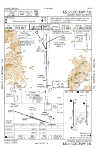
IAC chart of KEUG
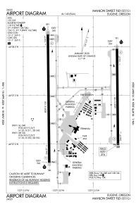
 ADC chart of KEUG
 Satellite view of KEUG

ADC chart of KEUG
Satellite view of KEUG
Sorry, we have no imagery here.
Sorry, we have no imagery here.
Sorry, we have no imagery here.
Sorry, we have no imagery here.
Sorry, we have no imagery here.
Sorry, we have no imagery here.


KEUG - Mahlon Sweet Fld
Located in Eugene, United States
ICAO - EUG, IATA - EUG
Data provided by AirmateGeneral information
Coordinates: N44°7'28" W123°12'43"
Elevation is 373 feet MSL.
Magnetic variation is 15° East View others Airports in Oregon
Operational data
Special qualification required
Current time UTC:
Current local time:
Weather
METAR: KEUG 170054Z 12009KT 9SM FEW011 SCT029 OVC055 06/03 A2971 RMK AO2 RAE2357B19E33 SLP063 P0001 T00560033 $
TAF: KEUG 162320Z 1700/1724 10014KT 5SM -RA BR FEW007 BKN024 OVC035 FM170400 12007KT 6SM -RA BKN025 FM170700 32005KT P6SM -RA BKN019 FM171900 30005KT P6SM -SHRA BKN021 FM172300 28010KT P6SM -SHRA SCT030 BKN050
Communications frequencies: [VIEW]
Runways:
| RWY identifier | QFU | Length (ft) | Width (ft) | Surface | LDA (ft) |
| 16L | 179° | 6000 | 150 | ASPH | 6000 |
| 34R | 359° | 6000 | 150 | ASPH | 6000 |
| 16R | 179° | 8009 | 150 | ASPH | 8009 |
| 34L | 359° | 8009 | 150 | ASPH | 8009 |
Airport contact information
Address: Eugene United States
Satellite view of KEUG
Sorry, we have no imagery here.
Sorry, we have no imagery here.
Sorry, we have no imagery here.
Sorry, we have no imagery here.
Sorry, we have no imagery here.
Sorry, we have no imagery here.