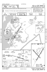
IAC chart of KESN
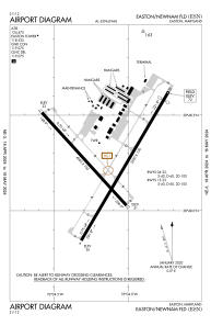
 ADC chart of KESN
 Satellite view of KESN
ADC chart of KESN
Satellite view of KESN
Sorry, we have no imagery here.
Sorry, we have no imagery here.
Sorry, we have no imagery here.
Sorry, we have no imagery here.
Sorry, we have no imagery here.
Sorry, we have no imagery here.


KESN - Easton/Newnam Fld
Located in Easton, United States
ICAO - ESN, IATA - ESN
Data provided by AirmateGeneral information
Coordinates: N38°48'15" W76°4'8"
Elevation is 72 feet MSL.
Magnetic variation is -10° East View others Airports in Maryland
Operational data
Special qualification required
Current time UTC:
Current local time:
Weather
METAR: KESN 230505Z AUTO 34011KT 10SM CLR 09/M01 A3000 RMK AO2 T00891005
Communications frequencies: [VIEW]
Runways:
| RWY identifier | QFU | Length (ft) | Width (ft) | Surface | LDA (ft) |
| 04 | 31° | 5500 | 100 | ASPH | 4775 |
| 22 | 211° | 5500 | 100 | ASPH | 5175 |
| 15 | 138° | 4003 | 100 | ASPH | |
| 33 | 318° | 4003 | 100 | ASPH |
Airport contact information
Address: Easton United States
Other aviation service providers
Flight schools

Satellite view of KESN
Sorry, we have no imagery here.
Sorry, we have no imagery here.
Sorry, we have no imagery here.
Sorry, we have no imagery here.
Sorry, we have no imagery here.
Sorry, we have no imagery here.