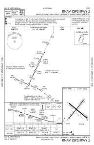
IAC chart of KEKN
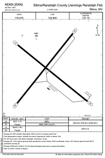
 ADC chart of KEKN
 Satellite view of KEKN
ADC chart of KEKN
Satellite view of KEKN
Sorry, we have no imagery here.
Sorry, we have no imagery here.
Sorry, we have no imagery here.
Sorry, we have no imagery here.
Sorry, we have no imagery here.
Sorry, we have no imagery here.


KEKN - Elkins/Randolph County (Jennings Randolph Fld)
Located in Elkins, United States
ICAO - EKN, IATA - EKN
Data provided by AirmateGeneral information
Coordinates: N38°53'22" W79°51'26"
Elevation is 1987 feet MSL.
Magnetic variation is -07° East View others Airports in West Virginia
Operational data
Special qualification required
Current time UTC:
Current local time:
Weather
METAR: KEKN 181451Z AUTO 00000KT 10SM CLR 08/M02 A3017 RMK AO2 SLP235 T00781022 58010 $
Communications frequencies: [VIEW]
Runways:
| RWY identifier | QFU | Length (ft) | Width (ft) | Surface | LDA (ft) |
| 05 | 39° | 4501 | 75 | ASPH | |
| 23 | 219° | 4501 | 75 | ASPH | |
| 14 | 129° | 4544 | 140 | ASPH | |
| 32 | 309° | 4544 | 140 | ASPH |
Airport contact information
Address: Elkins United States
Satellite view of KEKN
Sorry, we have no imagery here.
Sorry, we have no imagery here.
Sorry, we have no imagery here.
Sorry, we have no imagery here.
Sorry, we have no imagery here.
Sorry, we have no imagery here.