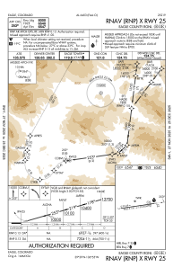
IAC chart of KEGE
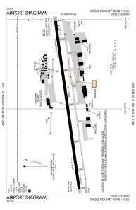
 ADC chart of KEGE
 Satellite view of KEGE

ADC chart of KEGE
Satellite view of KEGE
Sorry, we have no imagery here.
Sorry, we have no imagery here.
Sorry, we have no imagery here.
Sorry, we have no imagery here.
Sorry, we have no imagery here.
Sorry, we have no imagery here.


KEGE - Eagle County Rgnl
Located in Eagle, United States
ICAO - EGE, IATA - EGE
Data provided by AirmateGeneral information
Coordinates: N39°38'34" W106°54'57"
Elevation is 6547 feet MSL.
Magnetic variation is 09° East View others Airports in Colorado
Operational data
Special qualification required
Current time UTC:
Current local time:
Weather
METAR: KEGE 180456Z AUTO 09006KT 10SM CLR 04/M04 A2980 RMK AO2 SLP061 T00391044
TAF: KEGE 172324Z 1800/1824 22015G27KT P6SM BKN100 WS020/22045KT FM180300 17012G22KT P6SM BKN100 WS020/21035KT FM180700 24019G29KT P6SM BKN080 WS020/21035KT FM181500 24029G37KT P6SM VCSH BKN045 FM181800 27020G25KT 1SM -SHSN OVC025
Communications frequencies: [VIEW]
Runways:
| RWY identifier | QFU | Length (ft) | Width (ft) | Surface | LDA (ft) |
| 07 | 82° | 9000 | 150 | ASPH | 9000 |
| 25 | 262° | 9000 | 150 | ASPH | 8000 |
Airport contact information
Address: Eagle United States
Other aviation service providers
Flight schools

Satellite view of KEGE
Sorry, we have no imagery here.
Sorry, we have no imagery here.
Sorry, we have no imagery here.
Sorry, we have no imagery here.
Sorry, we have no imagery here.
Sorry, we have no imagery here.