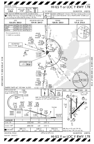
IAC chart of KEFD
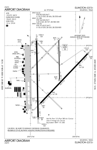
 ADC chart of KEFD
 Satellite view of KEFD
ADC chart of KEFD
Satellite view of KEFD
Sorry, we have no imagery here.
Sorry, we have no imagery here.
Sorry, we have no imagery here.
Sorry, we have no imagery here.
Sorry, we have no imagery here.
Sorry, we have no imagery here.


KEFD - Ellington
Located in Houston, United States
ICAO - EFD, IATA - EFD
Data provided by AirmateGeneral information
Coordinates: N29°36'26" W95°9'32"
Elevation is 32 feet MSL.
Magnetic variation is 05° East View others Airports in Texas
Operational data
Special qualification required
Current time UTC:
Current local time:
Weather
METAR: KEFD 201054Z 15008KT 6SM BR BKN016 26/24 A2971
TAF: TAF KEFD 200400Z 2004/2110 15016G22KT 9999 BKN016 BKN030 QNH2968INS BECMG 2018/2019 20010G20KT 9000 -SHRA BKN017 OVC024 QNH2979INS BECMG 2021/2022 VRB06KT 9999 NSW FEW007 BKN014 OVC022 QNH2979INS TX30/2018Z TN21/2004Z
Communications frequencies: [VIEW]
Runways:
| RWY identifier | QFU | Length (ft) | Width (ft) | Surface | LDA (ft) |
| 04 | 44° | 8001 | 150 | CONC | 8001 |
| 22 | 224° | 8001 | 150 | CONC | 8001 |
| 17L | 179° | 4609 | 75 | CONC | 4609 |
| 35R | 359° | 4609 | 75 | CONC | 4609 |
| 17R | 179° | 9001 | 150 | CONC | 9001 |
| 35L | 359° | 9001 | 150 | CONC | 9001 |
Airport contact information
Address: Houston United States
Other aviation service providers
Flight schools

Satellite view of KEFD
Sorry, we have no imagery here.
Sorry, we have no imagery here.
Sorry, we have no imagery here.
Sorry, we have no imagery here.
Sorry, we have no imagery here.
Sorry, we have no imagery here.