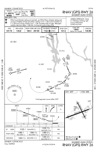
IAC chart of KDXR
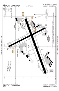
 ADC chart of KDXR
 Satellite view of KDXR
ADC chart of KDXR
Satellite view of KDXR
Sorry, we have no imagery here.
Sorry, we have no imagery here.
Sorry, we have no imagery here.
Sorry, we have no imagery here.
Sorry, we have no imagery here.
Sorry, we have no imagery here.


KDXR - Danbury Muni
Located in Danbury, United States
ICAO - DXR, IATA - DXR
Data provided by AirmateGeneral information
Coordinates: N41°22'18" W73°28'56"
Elevation is 456 feet MSL.
Magnetic variation is -14° East View others Airports in Connecticut
Operational data
Special qualification required
Current time UTC:
Current local time:
Weather
METAR: KDXR 190953Z AUTO 33007KT 10SM CLR 12/07 A2973 RMK AO2 SLP064 T01170072
Communications frequencies: [VIEW]
Runways:
| RWY identifier | QFU | Length (ft) | Width (ft) | Surface | LDA (ft) |
| 08 | 70° | 4421 | 150 | ASPH | |
| 26 | 250° | 4421 | 150 | ASPH | |
| 17 | 153° | 3135 | 100 | ASPH | |
| 35 | 333° | 3135 | 100 | ASPH |
Airport contact information
Address: Danbury United States
Other aviation service providers
Flight schools

Centennial Helicopters, Inc.
Centennial Helicopters, Inc.
chi@centennialhelicopters.com+1(203)798-9632
Satellite view of KDXR
Sorry, we have no imagery here.
Sorry, we have no imagery here.
Sorry, we have no imagery here.
Sorry, we have no imagery here.
Sorry, we have no imagery here.
Sorry, we have no imagery here.