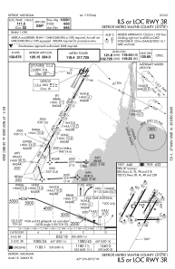
IAC chart of KDTW
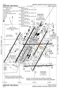
 ADC chart of KDTW
 Satellite view of KDTW
ADC chart of KDTW
Satellite view of KDTW
Sorry, we have no imagery here.
Sorry, we have no imagery here.
Sorry, we have no imagery here.
Sorry, we have no imagery here.
Sorry, we have no imagery here.
Sorry, we have no imagery here.


KDTW - Detroit Metro Wayne County
Located in Detroit, United States
ICAO - DTW, IATA - DTW
Data provided by AirmateGeneral information
Coordinates: N42°12'45" W83°21'12"
Elevation is 645 feet MSL.
Magnetic variation is -07° East View others Airports in Michigan
Operational data
Special qualification required
Current time UTC:
Current local time:
Weather
METAR: KDTW 280953Z 07004KT 10SM BKN040 OVC055 07/01 A3010 RMK AO2 SLP194 T00670006 $
TAF: KDTW 280904Z 2809/2912 11006KT P6SM BKN035 OVC060 FM281100 12008KT P6SM BKN022 OVC045 FM281300 14010KT P6SM -SHRA BKN008 OVC018 FM281700 19012KT 6SM -SHRA SCT008 OVC012 FM282100 21014G22KT P6SM SCT050 BKN070 FM290200 22016G24KT P6SM SCT080 BKN200
Communications frequencies: [VIEW]
Runways:
| RWY identifier | QFU | Length (ft) | Width (ft) | Surface | LDA (ft) |
| 03L | 29° | 8501 | 150 | CONC | 8501 |
| 21R | 209° | 8501 | 150 | CONC | 8501 |
| 03R | 29° | 10001 | 150 | CONC | 10001 |
| 21L | 209° | 10001 | 150 | CONC | 10001 |
| 04L | 29° | 10000 | 150 | CONC | 10000 |
| 22R | 209° | 10000 | 150 | CONC | 10000 |
| 04R | 29° | 12003 | 200 | CONC | 11494 |
| 22L | 209° | 12003 | 200 | CONC | 12003 |
| 04X | 29° | 0 | 0 | ||
| 22X | 209° | 0 | 0 | ||
| 09L | 89° | 8708 | 150 | CONC | 8618 |
| 27R | 269° | 8708 | 150 | CONC | 8708 |
| 09R | 89° | 8500 | 150 | CONC | 8500 |
| 27L | 269° | 8500 | 150 | CONC | 8500 |
Airport contact information
Address: Detroit United States
Satellite view of KDTW
Sorry, we have no imagery here.
Sorry, we have no imagery here.
Sorry, we have no imagery here.
Sorry, we have no imagery here.
Sorry, we have no imagery here.
Sorry, we have no imagery here.