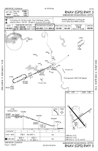
IAC chart of KDTN
 ADC chart of KDTN
 Satellite view of KDTN
ADC chart of KDTN
Satellite view of KDTN
Sorry, we have no imagery here.
Sorry, we have no imagery here.
Sorry, we have no imagery here.
Sorry, we have no imagery here.
Sorry, we have no imagery here.
Sorry, we have no imagery here.


KDTN - Shreveport Downtown
Located in Shreveport, United States
ICAO - DTN, IATA - DTN
Data provided by AirmateGeneral information
Coordinates: N32°32'27" W93°44'38"
Elevation is 179 feet MSL.
Magnetic variation is 01° East View others Airports in Louisiana
Operational data
Special qualification required
Current time UTC:
Current local time:
Weather
METAR: KDTN 061753Z 35008KT 10SM OVC020 13/08 A3001 RMK AO2 SLP161 60000 T01280083 10128 20100 58003
Communications frequencies: [VIEW]
Runways:
| RWY identifier | QFU | Length (ft) | Width (ft) | Surface | LDA (ft) |
| 05 | 55° | 4198 | 75 | ASPH | |
| 23 | 235° | 4198 | 75 | ASPH | |
| 14 | 140° | 5016 | 150 | ASPH | |
| 32 | 320° | 5016 | 150 | ASPH |
Airport contact information
Address: Shreveport United States
Other aviation service providers
Repair station

Flight schools

Satellite view of KDTN
Sorry, we have no imagery here.
Sorry, we have no imagery here.
Sorry, we have no imagery here.
Sorry, we have no imagery here.
Sorry, we have no imagery here.
Sorry, we have no imagery here.