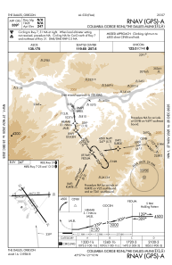
IAC chart of KDLS
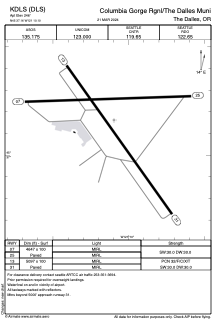
 ADC chart of KDLS
 Satellite view of KDLS
ADC chart of KDLS
Satellite view of KDLS
Sorry, we have no imagery here.
Sorry, we have no imagery here.
Sorry, we have no imagery here.
Sorry, we have no imagery here.
Sorry, we have no imagery here.
Sorry, we have no imagery here.


KDLS - Columbia Gorge Rgnl/The Dalles Muni
Located in The Dalles, United States
ICAO - DLS, IATA - DLS
Data provided by AirmateGeneral information
Coordinates: N45°37'10" W121°10'6"
Elevation is 246 feet MSL.
Magnetic variation is 15° East View others Airports in Oregon
Operational data
Special qualification required
Current time UTC:
Current local time:
Weather
METAR: KDLS 290353Z AUTO 31016G22KT 10SM CLR 10/03 A2991 RMK AO2 SLP130 T01000033 $
TAF: KDLS 282330Z 2900/2924 31013G24KT P6SM OVC080 FM290500 30006KT P6SM BKN100 FM292000 31011KT P6SM SCT070
Communications frequencies: [VIEW]
Runways:
| RWY identifier | QFU | Length (ft) | Width (ft) | Surface | LDA (ft) |
| 07 | 88° | 4647 | 100 | ASPH | |
| 25 | 268° | 4647 | 100 | ASPH | |
| 13 | 145° | 5097 | 100 | ASPH | |
| 31 | 325° | 5097 | 100 | ASPH |
Airport contact information
Address: The Dalles United States
Other aviation service providers
Flight schools

Gorge Aviation Services, Llc
Gorge Aviation Services, Llc
rolf@gorgeaviationservices.com+1(509)767-0005
Satellite view of KDLS
Sorry, we have no imagery here.
Sorry, we have no imagery here.
Sorry, we have no imagery here.
Sorry, we have no imagery here.
Sorry, we have no imagery here.
Sorry, we have no imagery here.