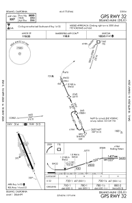
carte IAC de KDLO
 carte ADC de KDLO
 Vue satellite de KDLO

carte ADC de KDLO
Vue satellite de KDLO
Sorry, we have no imagery here.
Sorry, we have no imagery here.
Sorry, we have no imagery here.
Sorry, we have no imagery here.
Sorry, we have no imagery here.
Sorry, we have no imagery here.


KDLO - Delano Muni
Situé à Delano, United States
ICAO - DLO, IATA -
Données fournies par AirmateInformation générale
Coordonnées: N35°44'44" W119°14'11"
Élévation : 316 feet MSL.
Variation magnétique : 12° East Voir autres Aéroports à California
Données opérationnelles
Special qualification required
Heure actuelle UTC:
Heure actuelle locale:
Météo
METAR: KDLO 191715Z AUTO 00000KT 10SM CLR 11/04 A3039 RMK AO2 T01100035
Fréquences de communication: [VIEW]
Pistes:
| Identifiant RWY | QFU | Longueur (ft) | Largeur (ft) | Surface | LDA (ft) |
| 15 | 159° | 5659 | 75 | ASPH | |
| 33 | 339° | 5659 | 75 | ASPH |
Coordonnées de l'aéroport
Adresse: Delano United States
Vue satellite de KDLO
Sorry, we have no imagery here.
Sorry, we have no imagery here.
Sorry, we have no imagery here.
Sorry, we have no imagery here.
Sorry, we have no imagery here.
Sorry, we have no imagery here.