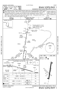
IAC chart of KDLL
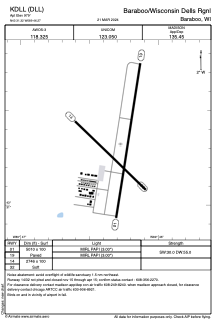
 ADC chart of KDLL
 Satellite view of KDLL
ADC chart of KDLL
Satellite view of KDLL
Sorry, we have no imagery here.
Sorry, we have no imagery here.
Sorry, we have no imagery here.
Sorry, we have no imagery here.
Sorry, we have no imagery here.
Sorry, we have no imagery here.


KDLL - Baraboo/Wisconsin Dells Rgnl
Located in Baraboo, United States
ICAO - DLL, IATA -
Data provided by AirmateGeneral information
Coordinates: N43°31'19" W89°46'16"
Elevation is 980 feet MSL.
Magnetic variation is -01° East View others Airports in Wisconsin
Operational data
Special qualification required
Current time UTC:
Current local time:
Weather
METAR: KDLL 121815Z AUTO 21011G15KT 10SM CLR 16/00 A3007 RMK AO2 T01590002
Communications frequencies: [VIEW]
Runways:
| RWY identifier | QFU | Length (ft) | Width (ft) | Surface | LDA (ft) |
| 01 | 9° | 5010 | 100 | ASPH | |
| 19 | 189° | 5010 | 100 | ASPH | |
| 14 | 134° | 2725 | 100 | GRASS | |
| 32 | 314° | 2725 | 100 | GRASS |
Airport contact information
Address: Baraboo United States
Other aviation service providers
Flight schools

Satellite view of KDLL
Sorry, we have no imagery here.
Sorry, we have no imagery here.
Sorry, we have no imagery here.
Sorry, we have no imagery here.
Sorry, we have no imagery here.
Sorry, we have no imagery here.