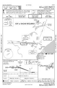
IAC chart of KDLH
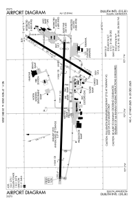
 ADC chart of KDLH
 Satellite view of KDLH
ADC chart of KDLH
Satellite view of KDLH
Sorry, we have no imagery here.
Sorry, we have no imagery here.
Sorry, we have no imagery here.
Sorry, we have no imagery here.
Sorry, we have no imagery here.
Sorry, we have no imagery here.


KDLH - Duluth Intl
Located in Duluth, United States
ICAO - DLH, IATA - DLH
Data provided by AirmateGeneral information
Coordinates: N46°50'31" W92°11'36"
Elevation is 1427 feet MSL.
Magnetic variation is -01° East View others Airports in Minnesota
Operational data
Special qualification required
Current time UTC:
Current local time:
Weather
METAR: KDLH 242255Z 07003KT 10SM FEW039 FEW070 SCT120 14/02 A3023 RMK AO2 SLP248 T01390022 $
TAF: KDLH 242326Z 2500/2524 10005KT P6SM SCT050 FM250600 VRB02KT 4SM BR SKC FM251000 VRB02KT 2SM BR SKC FM251300 VRB02KT P6SM SKC FM251600 09004KT P6SM FEW080
Communications frequencies: [VIEW]
Runways:
| RWY identifier | QFU | Length (ft) | Width (ft) | Surface | LDA (ft) |
| 03 | 32° | 5719 | 150 | ASPH | 5719 |
| 21 | 212° | 5719 | 150 | ASPH | 5719 |
| 09 | 92° | 10591 | 150 | CONC | 10062 |
| 27 | 272° | 10591 | 150 | CONC | 10062 |
Airport contact information
Address: Duluth United States
Other aviation service providers
Flight schools

Satellite view of KDLH
Sorry, we have no imagery here.
Sorry, we have no imagery here.
Sorry, we have no imagery here.
Sorry, we have no imagery here.
Sorry, we have no imagery here.
Sorry, we have no imagery here.