


KDLF - Laughlin Afb
Located in Del Rio, United States
ICAO - DLF, IATA - DLF
Data provided by AirmateGeneral information
Coordinates: N29°21'34" W100°46'41"
Elevation is 1081 feet MSL.
Magnetic variation is 07° East View others Airports in Texas
Operational data
Special qualification required
Current time UTC:
Current local time:
Weather
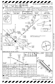
METAR: KDLF 182055Z AUTO 12014KT 10SM OVC034 25/15 A3005 RMK AO2 SLP166 T02450154 57021
TAF: TAF KDLF 181900Z 1819/2001 14012G20KT 9999 VCSH BKN030 BKN050 QNH3006INS TEMPO 1819/1824 15020G30KT BKN020 BECMG 1907/1908 12008KT 9999 NSW BKN020 QNH3013INS TEMPO 1912/1916 8000 -DZ BKN010 BECMG 1916/1917 15015G25KT 9999 VCSH BKN030 QNH30115INS TX26/1821Z TN19/1912Z
Communications frequencies: [VIEW]
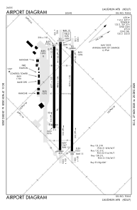
Runways:
| RWY identifier | QFU | Length (ft) | Width (ft) | Surface | LDA (ft) |
| 13C | 0° | 8852 | 150 | OTHER | |
| 31C | 0° | 8852 | 150 | OTHER | |
| 13L | 0° | 8316 | 150 | OTHER | |
| 31R | 0° | 8316 | 150 | OTHER | |
| 13R | 0° | 6571 | 150 | ASPH | |
| 31L | 0° | 6571 | 150 | ASPH |
Airport contact information
Address: Del Rio United States