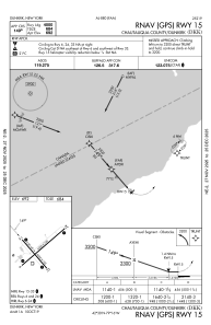
IAC chart of KDKK
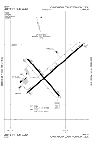
 ADC chart of KDKK
 Satellite view of KDKK
ADC chart of KDKK
Satellite view of KDKK
Sorry, we have no imagery here.
Sorry, we have no imagery here.
Sorry, we have no imagery here.
Sorry, we have no imagery here.
Sorry, we have no imagery here.
Sorry, we have no imagery here.


KDKK - Chautauqua County/Dunkirk
Located in Dunkirk, United States
ICAO - DKK, IATA - DKK
Data provided by AirmateGeneral information
Coordinates: N42°29'38" W79°16'16"
Elevation is 692 feet MSL.
Magnetic variation is -10° East View others Airports in New York
Operational data
Special qualification required
Current time UTC:
Current local time:
Weather
METAR: KDKK 280653Z AUTO 23007KT 10SM CLR 04/00 A3017 RMK AO2 SLP222 T00440000
Communications frequencies: [VIEW]
Runways:
| RWY identifier | QFU | Length (ft) | Width (ft) | Surface | LDA (ft) |
| 06 | 49° | 6000 | 100 | ASPH | |
| 24 | 229° | 6000 | 100 | ASPH | |
| 15 | 139° | 4000 | 100 | ASPH | |
| 33 | 319° | 4000 | 100 | ASPH |
Airport contact information
Address: Dunkirk United States
Other aviation service providers
Flight schools

Satellite view of KDKK
Sorry, we have no imagery here.
Sorry, we have no imagery here.
Sorry, we have no imagery here.
Sorry, we have no imagery here.
Sorry, we have no imagery here.
Sorry, we have no imagery here.