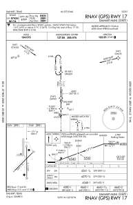
IAC chart of KDHT
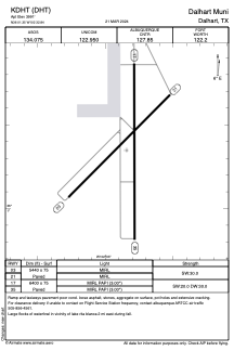
 ADC chart of KDHT
 Satellite view of KDHT
ADC chart of KDHT
Satellite view of KDHT
Sorry, we have no imagery here.
Sorry, we have no imagery here.
Sorry, we have no imagery here.
Sorry, we have no imagery here.
Sorry, we have no imagery here.


KDHT - Dalhart Muni
Located in Dalhart, United States
ICAO - DHT, IATA - DHT
Data provided by AirmateGeneral information
Coordinates: N36°1'21" W102°32'51"
Elevation is 3991 feet MSL.
Magnetic variation is 09° East View others Airports in Texas
Operational data
Special qualification required
Current time UTC:
Current local time:
Weather
METAR: KDHT 302353Z AUTO 10011KT 10SM CLR 14/03 A2984 RMK AO2 SLP087 T01440028 10167 20106 58008
TAF: KDHT 302328Z 3100/3124 13009KT P6SM BKN200 FM310600 06008KT P6SM FEW230 FM312100 19011KT P6SM FEW250
Communications frequencies: [VIEW]
Runways:
| RWY identifier | QFU | Length (ft) | Width (ft) | Surface | LDA (ft) |
| 03 | 45° | 5440 | 75 | ASPH | |
| 21 | 225° | 5440 | 75 | ASPH | |
| 17 | 180° | 6400 | 75 | ASPH | |
| 35 | 360° | 6400 | 75 | ASPH |
Airport contact information
Address: Dalhart United States
Satellite view of KDHT
Sorry, we have no imagery here.
Sorry, we have no imagery here.
Sorry, we have no imagery here.
Sorry, we have no imagery here.
Sorry, we have no imagery here.