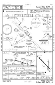
IAC chart of KDHN
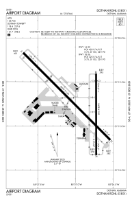
 ADC chart of KDHN
 Satellite view of KDHN

ADC chart of KDHN
Satellite view of KDHN
Sorry, we have no imagery here.
Sorry, we have no imagery here.
Sorry, we have no imagery here.
Sorry, we have no imagery here.
Sorry, we have no imagery here.
Sorry, we have no imagery here.


KDHN - Dothan Rgnl
Located in Dothan, United States
ICAO - DHN, IATA - DHN
Data provided by AirmateGeneral information
Coordinates: N31°19'16" W85°26'58"
Elevation is 400 feet MSL.
Magnetic variation is -03° East View others Airports in Alabama
Operational data
Special qualification required
Current time UTC:
Current local time:
Weather
METAR: KDHN 150753Z AUTO 12007KT 10SM CLR 16/13 A2987 RMK AO2 SLP111 T01560128 $
TAF: KDHN 150520Z 1506/1606 16010KT P6SM BKN100 FM151500 16017G25KT P6SM BKN040 BKN100 FM151900 18020G35KT P6SM BKN020 FM160000 17011G24KT P6SM VCSH OVC012 WS020/19050KT FM160400 24030G45KT 1SM +TSRA OVC007CB
Communications frequencies: [VIEW]
Runways:
| RWY identifier | QFU | Length (ft) | Width (ft) | Surface | LDA (ft) |
| 14 | 135° | 8499 | 150 | ASPH | 8496 |
| 32 | 315° | 8499 | 150 | ASPH | 8496 |
| 18 | 180° | 5498 | 100 | ASPH | 5000 |
| 36 | 360° | 5498 | 100 | ASPH | 5000 |
Airport contact information
Address: Dothan United States
Other aviation service providers
Flight schools

Satellite view of KDHN
Sorry, we have no imagery here.
Sorry, we have no imagery here.
Sorry, we have no imagery here.
Sorry, we have no imagery here.
Sorry, we have no imagery here.
Sorry, we have no imagery here.