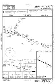
IAC chart of KDFI
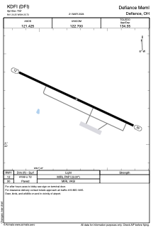
 ADC chart of KDFI
 Satellite view of KDFI
ADC chart of KDFI
Satellite view of KDFI
Sorry, we have no imagery here.
Sorry, we have no imagery here.
Sorry, we have no imagery here.
Sorry, we have no imagery here.
Sorry, we have no imagery here.
Sorry, we have no imagery here.


KDFI - Defiance Meml
Located in Defiance, United States
ICAO - DFI, IATA - DFI
Data provided by AirmateGeneral information
Coordinates: N41°20'15" W84°25'44"
Elevation is 706 feet MSL.
Magnetic variation is -05° East View others Airports in Ohio
Operational data
Special qualification required
Current time UTC:
Current local time:
Weather
METAR: KDFI 130053Z AUTO 12004KT 10SM CLR 09/M02 A3010 RMK AO2 SLP196 T00941022
Communications frequencies: [VIEW]
Runways:
| RWY identifier | QFU | Length (ft) | Width (ft) | Surface | LDA (ft) |
| 12 | 115° | 4199 | 72 | ASPH | |
| 30 | 295° | 4199 | 72 | ASPH |
Airport contact information
Address: Defiance United States
Other aviation service providers
Flight schools

Satellite view of KDFI
Sorry, we have no imagery here.
Sorry, we have no imagery here.