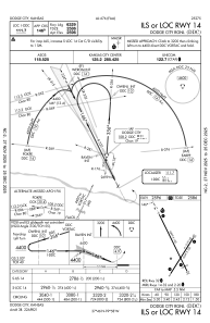
IAC chart of KDDC
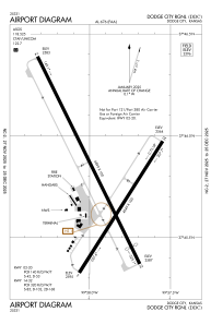
 ADC chart of KDDC
 Satellite view of KDDC
ADC chart of KDDC
Satellite view of KDDC
Sorry, we have no imagery here.
Sorry, we have no imagery here.
Sorry, we have no imagery here.
Sorry, we have no imagery here.
Sorry, we have no imagery here.
Sorry, we have no imagery here.


KDDC - Dodge City Rgnl
Located in Dodge City, United States
ICAO - DDC, IATA - DDC
Data provided by AirmateGeneral information
Coordinates: N37°45'47" W99°57'56"
Elevation is 2595 feet MSL.
Magnetic variation is 08° East View others Airports in Kansas
Operational data
Special qualification required
Current time UTC:
Current local time:
Weather
METAR: KDDC 212252Z AUTO 18014G25KT 7SM CLR 26/03 A2986 RMK AO2 PK WND 15027/2207 SLP094 T02610028
TAF: KDDC 212334Z 2200/2224 18013G20KT P6SM SCT200 FM220800 22007KT P6SM FEW200
Communications frequencies: [VIEW]
Runways:
| RWY identifier | QFU | Length (ft) | Width (ft) | Surface | LDA (ft) |
| 02 | 32° | 4649 | 100 | ASPH | 4649 |
| 20 | 212° | 4649 | 100 | ASPH | 4649 |
| 14 | 154° | 6899 | 100 | ASPH | 6329 |
| 32 | 334° | 6899 | 100 | ASPH | 6329 |
Airport contact information
Address: Dodge City United States
Other aviation service providers
Flight schools

Satellite view of KDDC
Sorry, we have no imagery here.
Sorry, we have no imagery here.
Sorry, we have no imagery here.
Sorry, we have no imagery here.
Sorry, we have no imagery here.
Sorry, we have no imagery here.