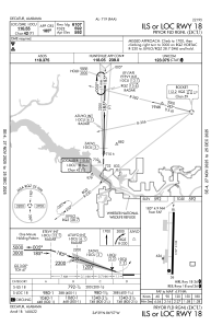
IAC chart of KDCU
 ADC chart of KDCU
 Satellite view of KDCU
ADC chart of KDCU
Satellite view of KDCU
Sorry, we have no imagery here.
Sorry, we have no imagery here.
Sorry, we have no imagery here.
Sorry, we have no imagery here.
Sorry, we have no imagery here.


KDCU - Pryor Fld Rgnl
Located in Decatur, United States
ICAO - DCU, IATA - DCU
Data provided by AirmateGeneral information
Coordinates: N34°39'15" W86°56'43"
Elevation is 592 feet MSL.
Magnetic variation is -04° East View others Airports in Alabama
Operational data
Special qualification required
Current time UTC:
Current local time:
Weather
METAR: KDCU 312053Z AUTO 34015G20KT 10SM OVC012 16/13 A2988 RMK AO2 SLP112 T01610133 53017 $
Communications frequencies: [VIEW]
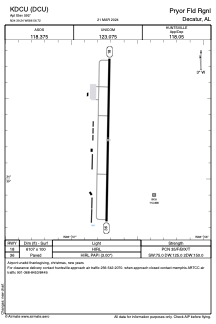
Runways:
| RWY identifier | QFU | Length (ft) | Width (ft) | Surface | LDA (ft) |
| 18 | 181° | 6107 | 100 | ASPH | |
| 36 | 1° | 6107 | 100 | ASPH |
Airport contact information
Address: Decatur United States
Satellite view of KDCU
Sorry, we have no imagery here.
Sorry, we have no imagery here.
Sorry, we have no imagery here.
Sorry, we have no imagery here.
Sorry, we have no imagery here.